| |
|
|
|
|
|
|
|
|
|
||||||||
| |
|
|
|
|
|
 |
|
|
|||||||||
 |
|
|
|
|
|
|
|
 |
|
||||||||
| |
|
|
|
||||||||||||||
| |
|
||||||||||||||||
| |
|
|
|
||||||||||||||
| |
|
|
|
||||||||||||||
| |
|
|
|
|
|||||||||||||
|
||||||||||||||||||||||||||||||||||||||||||||||||||||||||||||||||
29 October 07: The Possible City:
Wondering about Wandering
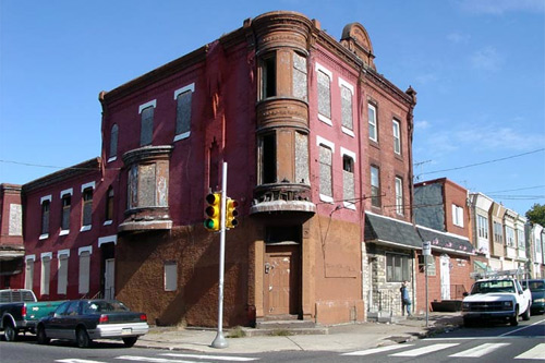 by Nathaniel Popkin October 29, 2007 Lending itself perfectly to aimless wandering, Buenos Aires is primarily a city of barrios. For many people, these are Buenos Aires' best sights, more intriguing than most museums, churches or monuments. --Rough Guide to Argentina Shall we think rigorously about aimless wandering? Inspiring literature, philosophy music, instilling the marvelous expansive feeling of being human, it is, after all, one the great joys -- and strengths -- of the city. You can hike in the woods and feel profoundly small and yet at ease; you can roam a city and feel utterly connected. In a city of neighborhoods, wandering implies leaving your own comfortable realm and heading out to territory unknown, unexplored, un-encountered. It invites the unplanned, unexpected, unrehearsed, which makes one's world larger and more interesting, one's city richer and ultimately, conversely, after a thousand wanderings, altogether more comfortable. I wander because I'm curious, because I need to relax, because I want to be stimulated. Philadelphia's intimate streets often oblige -- and they keep going, which pulls me along. And each time the city surprises. Each time it becomes more familiar. So I know it's rotten, boring, fragmented. Wandering only exposes the worn edges. Far from "lending itself perfectly" our city of neighborhoods is simply derisive to the idea of leaving the parochial block, of stopping somewhere on the way, of being able to find your way. The result is a place that thinks it is small when, in fact, it is huge; that thinks it is stifling when it might be freeing; that thinks it is homogenous when it is unendingly pluralistic; that defines neighborhood to mean "my neighborhood," never yours. It isn't a city of neighborhoods, rather a bunch of neighborhoods each of which thinks it is the entire city. That's a problem -- not just because it would be nice if it was easier to wander -- but because ultimately a city has to cohere in order to dazzle. A neighborhoods plan, therefore, can't be a plan for neighborhoods. Rather it must address the ways the parts of the city fit together to make the whole. And it must invent city-wide responses to shared problems. I will say this now, lest anyone is confused: our idiosyncratic neighborhoods are a terrific strength, perhaps more intriguing and certainly less polished than Center City. They are charming places with related but discreet histories, with traditions, with life cycles and daily rituals and institutions. We don't want to obliterate authenticity (or fetishize it, for that matter). Instead, we just want to treat each as critical to the whole; the treatments may vary. The first and best thing we can do for the neighborhoods is make Center City larger. Its current small size -- 3 square miles of the total 135 -- limits its ambition, circumscribes our identity, leads us to think that our city is small. It isn't -- Philadelphia is the 129th largest central city in the world. [source.] But it is ever-more dependent on what happens in those three square miles. Such a small area simply can't carry one so vast. It's like trying to balance the elephant on top of the pin. Center City is already growing of course, first by filling in, then by going up, now pushing out. Parts of what used to be South Philly and North Philly and West Philly are now really in practice Center City. We're merely going to put a name on those places -- a powerful brand name, in fact. (Keep in mind there is a difference between the Center City District (CCD) and Center City itself; the CCD already imagines a "greater" Center City but it isn't clear how exactly to translate the current system of assessment, which pays for services and capital improvements, to a much larger and less commercial area. A future installment of the Possible City will propose a fiscal device for doing so.) The strategy implicit is to leverage the success of Center City by physically extending its reach. Merely by growing vertically, even 1,000 feet up, isn't going to do. I propose to make Norris Street the northern boundary of the new Center City, Morris the southern. Norris to Morris, has a nice ring to it. The east of course is the Delaware. Do we cross the Schuylkill? Given Cira South and Penn Connects, this is already in motion. 48th Street should be the western boundary -- 48th north to Girard, including the Zoo. (University City, as Francisville and Brewerytown and Pennsport, would just be part of the center.) Now, at 12 square miles or so, we've made the center large enough to carry the load. I want to discuss for a moment the importance of physical scale and connections. Our goal is a city robust enough to be a joy to inhabit, where roaming is rewarded. To make this possible in practice we need to reinforce and redefine connections among places -- it's an act of improving accessibility. The best connector of all is Center City. Imagine Center City as a compass: it points in all directions; small in size it takes you only so far; much larger its capacity to connect has grown substantially -- out into the middle band of turn-of-the-century West Philly to Passyunk Avenue to Strawberry Mansion and up into Kensington. Readers may question how simply re-labeling something could have real, practical effect. We are re-labeling but we're also applying certain criteria for density, height, parking, transit, lighting, and commercial activity so that the new core becomes just as vital as the current, smaller one. Since most of the expanded area is already growing in population and generally pretty vital, these new criteria are already beginning to be met. A great deal of thought and nuanced planning will reveal how to respect current neighborhood patterns while raising the level of performance. Others might wonder if this is simply a gentrification plan, designed to make property more valuable; still more are saying here we go again: throwing money at Center City when it's the neighborhoods that need it. Trickle down? Everyone knows that's Voodoo Economics. Let's bracket those responses for now and assume this bit of surgery has been successful. The center is larger in scale and ambition. It has more resources; it has appropriate signage and lighting; transit is reorganized to enhance new connections -- and critically, transit signage reinforces the new identity with route and neighborhood maps displayed at bus, subway, rail, and trolley stops. Better legibility at the core will alone improve performance (imagine arriving by El at Front and Girard and being able to consult a map). Urban policy has failed in part because the federal government refuses to fairly distribute income. (In fact, as we know, just the opposite: it loves to exploit and widen the income gap.) State and local governments without the proper resources are therefore forced to redress inequality. They can't -- and yet urban policy has been caught up with that un-winnable proposition for forty years. So when we talk about making neighborhoods better it's assumed we mean crafting a response to poverty. That isn't our task here; rather we're interested in Philadelphia surviving. If it can survive then it is going to make an awful lot of people's lives better and more rewarding. There are two structural problems we'd better tackle. Everyone knows the first. Guns are killing places as much as people. Homicide is particularly corrosive because it pushes certain families out, including the families of victims, and it builds upon itself, it reproduces: one murder makes a handful more. Once the process begins, watch out! It's like dominoes falling. I don't have the answer to this but to hope that Pennsylvania allows Philadelphia to apply all the resources it can muster. (John Street's response to this crisis is right, on the face of it. Murders as a function of poverty increase during times of a widening gap between rich and poor; there isn't much one can do but push the congress to do its job. On the other hand his whimpering response indicates a lack of confidence in our own ability to respond and an unwillingness to experiment, things I suspect Mr. Nutter will not have to overcome.) The other structural problem works the same way, only more slowly, and you don't always see it happening. That problem is deferred maintenance. Our row houses are falling down. The first and most critical to go are the corners (you lose the best architecture and the corner store). Now there are hundreds of blocks that look like books on a shelf without bookends. We know what happens eventually. Yet -- yet! -- so much of the city is still intact -- there is still a chance to preserve the traditional fabric, the porches and bay windows, the evocative terracotta and metalwork that give places character and make them worth living in. There is still time. What we need is a carefully-mapped plan to catch blocks before they fall apart, preferably before the corners are lost. My guess is we have five years to intervene at scale. I propose a $10 billion fund (100,000 buildings at $100,000 each) to save, preserve, and renovate. In terms of environmental sustainability, neighborhood improvement, economic development, and fiscal responsibility, there is no more important thing the new Mayor can do. A fund like that in this city is asking for corruption. Robbery aside, we do need to invent a way to prioritize and leverage the investment we're about to make. This is called asset-based planning. We need to make the most of the (pretty amazing) assets we already have -- parks and other recreation centers, public institutions and cultural centers, and transit infrastructure. If we take a map of the city and circle all of those things and then find the overlap, we'll see where to prioritize the investment of the fund. (Doing so also reverses the current mode, which is to plan strictly from within each neighborhood without seeing the connections.) Let's take an example--Strawberry Mansion. 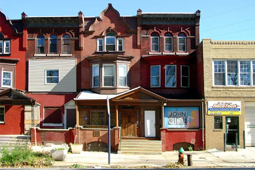 Here's Fairmount Park, the Coltrane House, the R7 (which doesn't have a stop there but should -- I wonder if it did once?), and Strawberry Mansion High School, altogether a concentration worth leveraging. As a result the park and other institutions become more accessible because their surroundings aren't falling apart; the city a little bit easier and more rewarding to roam. Are we ready yet? No? Indeed not. I want to return to something we just touched on -- access to Fairmount Park. Arguably our greatest resource, it's just not getting used enough. Part of the joy of roaming the city is getting into the park; aside from Kelly Drive, the park is accessed primarily by car -- and this makes it seem less accessible, especially to teenage kids who could sure use space to exert some energy. The park, like Center City, is also a connector. Making it more accessible is therefore critical. The best way to increase park use, of course, is to increase the number of people living around it. Beyond that there are a few bus lines that go to the park's edge, but fewer that cross it -- and no rail link (the Strawberry Mansion R7 stop might be useful). This is a subject worth its own investigation, perhaps as Philadelphia attempts to make the most of the renovation of Memorial Hall as the Please Touch Museum. There's still a bunch of connective tissue missing: that's the commercial avenues. This is also an act of leveraging. Most of these streets and avenues bind neighborhoods -- or in the current form, act as boundaries. Careful investment can heal two or three or four neighborhoods all at once. No city is worth roaming unless you can come upon a bookstore you've never heard of, or a taqueria or lunch counter or a place to get Vietnamese Hoagies. What's the use? But our neighborhood commercial streets are ragged, unpleasant, and boring. Even North Fifth Street, where you can find a menú del día to knock your socks off (El Bochinche, wow), is oppressively dull and sometimes a little frightening. These places need a combination stewardship, marketing, financing, streetscape improvements, lighting, evening programming, etc. Proper sidewalk lighting is the absolute key -- capable alone of transformation. You're wondering when I'm going to start talking about places. Enough of the theory, where specifically? Here, in a list, are some key locations. In a subsequent post, I'll carefully (re)consider them, imagining newfound roles for these locations. I will also spend some time thinking about the physical act of getting around Philadelphia. For a grid it sure isn't very legible. Here's my list: • Oxford Circle • Wayne Junction • North Philadelphia Station • Kensington and Allegheny • MCP site • Lancaster Avenue • Broad/Snyder/Passyunk • 52nd Street • Chester-Woodland-49th to 54th Street This is a very short list. It doesn't include Delaware waterfront, current Center City or expanded Center City locations -- but it might. I would love it if you would send me currently/potentially powerful locations anywhere in the city, places that right now have big impact -- or could with some careful investment: nathaniel.popkin@gmail.com. I'll add those locations to my list so that we can ultimately match ideas with specific locales. –Nathaniel Popkin  |
|
• 5 Oct 07: No other way • 21 Sept 07: Here is the Possible City |
